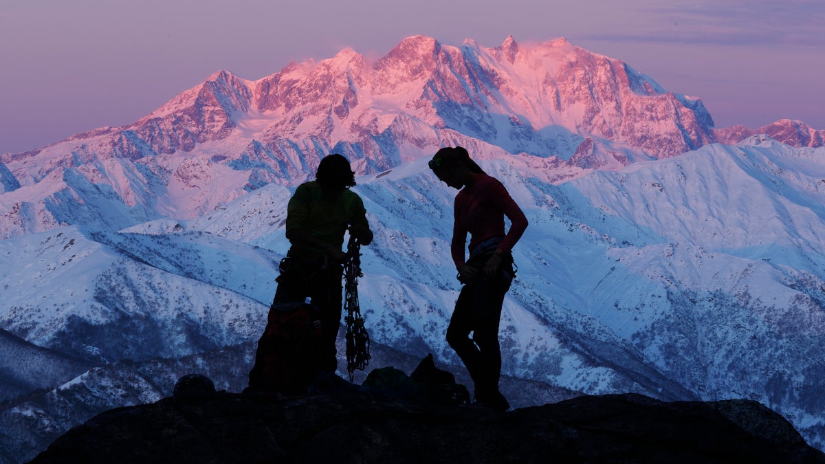

I love winter. The skiing, sledding with the kids, chopping firewood for the wood stove in the basement—some of my favorite adventures have been set to a snowy backdrop. But there’s nothing wrong with taking a break from the single-digit temperatures to get a little sunshine, especially as we reach the depths of the season, and as much of the country contends with a series of winter storms. Fortunately, our national park system has several premiere sites that offer a respite from the cold weather.
These are parks that come alive in the winter, with warm temps and surprisingly vibrant ecosystems that thrive when the rest of the country is huddling under a blanket of snow and ice.
Here are half a dozen national parks that are better in winter.
Death Valley National Park, California
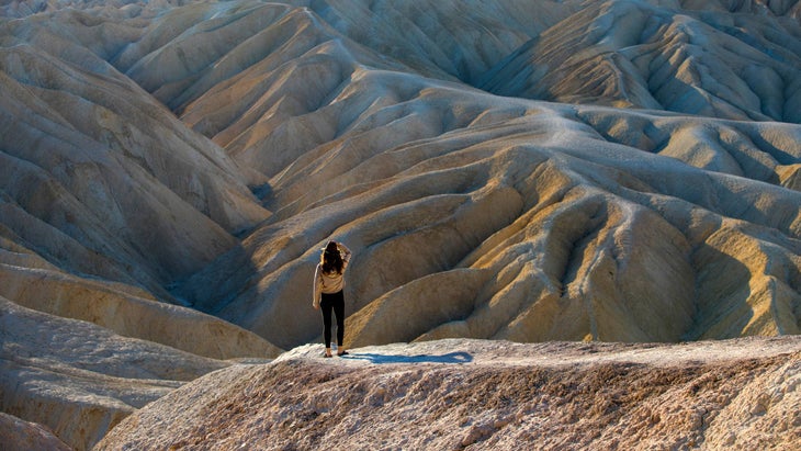
Death Valley National Park gets its name honestly. During summer, this broad swath of the Mojave Desert is borderline inhabitable. The deepest section of the valley is 282 feet below sea level, the lowest point in North America, and the heat gets trapped down there to the point where triple digit temperatures are the norm through July and August. But come winter, the park should be renamed “Pleasant Valley” thanks to the mild weather that’s ideal for a desert adventure. The average temperatures in February are in the low 70s, and come March, the mercury begins to creep into the low 80s. So now is the time to take that bucket list trip to the hottest, driest, most bizarre spot in the entire country.
What to do
There are a couple of experiences everyone has to have when visiting Death Valley, because they’re so unique. The first is walking to the salt flats of Badwater Basin, which sits at 285 feet below sea level, making it the lowest point in North America. It’s an easy two-mile out and back through a flat valley that encompasses 200 square miles, most of which is caked with salt deposits. You’ll find a thin lake close to the parking lot if there’s been enough rain in recent weeks. If it’s calm and sunny, you can see the reflection of the surrounding mountains on the surface of the water. The other mandatory visit is to the Mesquite Flats Sand Dunes, named for the gnarly trees that somehow thrive in the dry, sandy ecosystem. It’s only a two-mile hike to the tallest dune, which rises 185 feet from the valley floor, but you’ll be trudging through deep, shifting sand so don’t expect to hike at your normal pace. There are no official trails through the dunes, so you’re free to roam, and reenact scenes from Star Wars, since pieces of the movies were filmed here.
If you want a more adventurous hike that explores some of the park’s signature terrain, head to Mosaic Canyon Trail for a four-mile hike out and back through a narrow gorge with smooth rock walls. Route finding is straightforward (just follow the sandy wash) but you’ll have some scrambling to do as you encounter the occasional boulder jam and dry falls.
Death Valley also has some of the best scenic drive in our national park system. The Artists Palette Drive is the standard scenic road through the park, and it’s stunning as it passes through colorful desert hills. But if you want a true adventure from the comfort of your vehicle, head for Titus Canyon, a 27-mile long dirt road with mountain views, plenty of colorful rock formations, and a fun “narrows” section where the canyon walls squeeze to less than 20 feet apart. You’ll also have the chance to see petroglyphs and stop at a ghost town. You’ll have to wait for this adventure, though, as Titus Canyon road is closed to vehicles and bikes until the fall of 2026 due to flood damage.
Where to stay
Winter is a great time to pitch a tent in Death Valley. Furnace Creek is the largest campground in the park, and the only spot where you can reserve a site ahead of time ($30 a night, book at least two days in advance). Or, try to get a first come/first serve spot at Texas Springs Campground, which has mountain views and some sites shaded from trees ($20 per site).
Everglades National Park, Florida
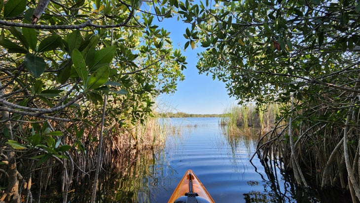
It would be downright insane to explore Everglades National Park in the summer. The 1.5-million-acre park envelopes the southern tip of Florida, which is plenty hot to be sure (temps are routinely in the 90s here during summer), but it’s the bugs that make it unbearable during the warmer months. The park is full of mosquitos and other biting flies that thrive in the hot, rainy summers, making it no place for civilized humans. But from November to April, most of those bugs are dormant. It’s warm instead of hot, with temperatures idling in the mid-70s, and there’s way less rain. Bonus: the wildlife is more active, as alligators seek out sunny spots for warmth and migrating birds flock to the area for the same reason we do—sunshine. It’s the perfect weather for exploring an ecosystem that’s been dubbed “a river of grass.”
What to do
The Everglades is a paddler’s park. Yeah, you can do some hiking, and there are airboat tours if you’re into that sort of thing, but if you can handle a canoe or a paddle board, the soggy landscape is yours to explore. Also, paddling is quiet and a great way to see local wildlife. The park is huge though, so you’re not going to see it all. Focus on the Flamingo region, which has the best marked paddle trails and a good variety of terrain, as you have sawgrass prairies, ponds, mangrove tunnels, and bays to explore.
The classic half-day trip is Nine Mile Pond, a 5.2-mile marked loop that meanders through a mix of ponds and prairie grass marshland lined by islands that sport healthy mangrove forests. The water is typically clear enough where you can see the bottom, so it’s an excellent place to spot fish as you paddle. You can rent boats from Flamingo Adventures (from $38 for a half day) and navigate the route solo, or sign up for a guided paddle with the Everglades Institute ($79 per person).
If you’re looking for an overnight adventure, consider paddling Hell’s Bay, where a marked trail leads you along narrow creeks and through a series of small ponds, all of which is well protected from the winds. Backcountry campsites and platforms (called chickees) are scattered throughout so you can pick your mileage. The route is narrow and twisting, so it will take you longer to cover miles than you think. Get a wilderness permit to camp ($21 administration fee and $2 per person per night).
Where to stay
Flamingo Lodge has hotel rooms, glamping tents, and even houseboats you can rent that will put you within striking distance of the action in the Everglades (from $149 a night for tents).
Saguaro National Park, Arizona
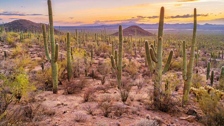
The giant saguaro is an iconic figure of the American West, a background player in Westerns and old children’s cartoons alike. And this tree-sized cactus only grows in parts of the Sonoran Desert that have the perfect balance of heat and rain. The cactus simply can’t handle freezing temps, which is how you know that an adventure inside Saguaro National Park is bound to be warm, even in the dead of winter. Here, temps bounce between the high 50s and the mid 70s which is exactly what we’re looking for at this time of year. The cacti agree; an estimated two million saguaro live inside the park.
Saguaro is divided into two districts separated by the city of Tucson, with the Rincon Mountain District on the east side of town and the Tucson Mountain District on the west side of town. And Saguaro isn’t just about big, beautiful cacti. Elevations inside the park reach almost 9,000 feet, with its mountains acting as “sky islands,” a key wildlife corridor amidst the desert and development of Arizona, that connects the Rocky Mountains to the north with the Sierra Madre Mountains to the south. Roadrunners, javelinas and gila monsters thrive here, and petroglyphs can be found on rocks in the western district of the park. Altogether, Saguaro is 92,000 acres, with mountains, canyons, 200 miles of hiking trails, and iconic cacti that can grow to be 50 feet tall.
What to do
Tucson has a thriving cycling culture (I’ve spent several days mountain biking here). One of the most cherished road rides is the eight-mile Cactus Forest Drive, a paved loop road in the Rincon Mountain District. It’s a narrow, paved road through the lower elevations with non-stop desert and mountain views. Traffic is one way for most of the loop, and drivers are used to cyclists. Climbing is minimal, with less than 700 feet of elevation gain throughout, most of which comes in the form of rolling hills that play out like a roller coaster if you attack them with gusto. Bikes are also allowed to ride a 2.5-mile section of the Cactus Forest Trail, a fun piece of singletrack that winds past tall saguaros and connects on two points of Cactus Forest Drive. A sturdy gravel bike is the perfect tool for combining the paved road and singletrack trail.
Hikers should head to the Tucson Mountain District to tackle the 9.5-mile out and back Hugh Norris Trail, which climbs to the summit of 4,687-foot Wasson Peak, the highest point in the western district of the park. You’ll begin in a saguaro forest and then climb more than 2,000 feet to a ridgeline full of rock outcroppings and dramatic views across the Sonoran Desert, not to mention views of Tucson and the Rincon Mountains beyond.
Where to stay
Camping inside the park is remote and only accessible by backpacking. The best campground is Grass Shack, which has reliable water and shade from oak trees. You’re looking at a 10-mile one way hike that gains 2,200 feet to get there ($8 a night, get reservations in advance). If that’s not your cup of tea, remember that the city of Tucson splits the two districts of the park, so there are plenty of hotel, resort, and ranch options throughout town.
Tangue Verde Ranch sits on 640 acres near the eastern district of the park and has an upscale dude ranch vibe with lots of equestrian activities, but also resort goodies like a pool, hot tub, and yoga classes (from $627 a night with all-inclusive packages available).
Big Bend National Park, Texas
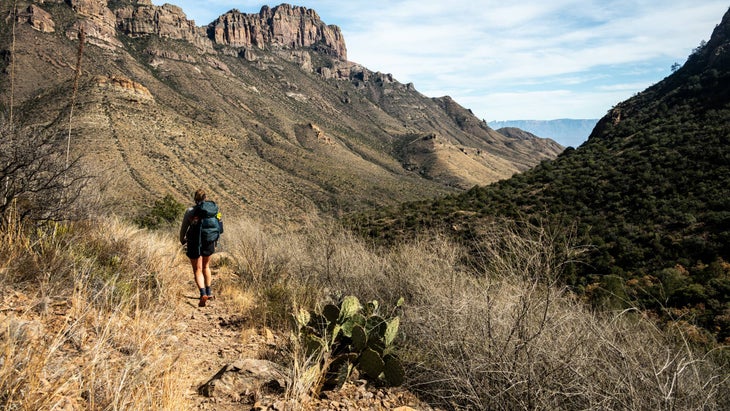
Looking for warm weather in the winter and isolation in the lower 48? Big Bend National Park is the spot for you. One of my favorite national parks, Big Bend covers a massive chunk of desert, canyons and mountains in far far West Texas where the Rio Grande carves a curvaceous border between the U.S. and Mexico. This is classic, Wild West terrain with an “edge of the world” vibe that delivers minimal crowds and maximum stars at night. Seriously, some of the most glorious night skies I’ve ever witnessed personally were above Big Bend National Park. There’s also canyon hiking, scenic driving (or cycling), countless species of cactus, wild burros, and even a hot springs you can soak in. I visited in the summer, and had to get all of my adventuring done between dawn and noon before the heat set in and I had to retreat to an air conditioned bar. You won’t have those constraints if you visit in the winter, when day time temps hover in the 70s. You might want to avoid the mountain sections of the park, though, as the elevations reach 8,000 feet and have been known to attract snow.
What to do
Big Bend is an adventure cyclist’s dreamscape. There are 160 miles of gravel and dirt roads where you likely won’t see any vehicles, as well as a 35-mile paved, scenic road that cuts through the heart of the park. So there are endless bike packing possibilities, but if you’re looking for a half-day or full-day adventure, consider riding the 13-mile Old Maverick Road, a gravel road that runs through the desert from the West Entrance Road near the small town of Terlingua to the head of Santa Elena Canyon. You’ll get views of the Chisos Mountains on the horizon and the vast desert stretching in every direction from the gravel along the way. If you don’t have a shuttle vehicle, you’re looking at a 26-mile out and back. Expect some washboard sections. If you want to stretch your legs, Old Maverick Road ends at the Santa Elena Canyon Trailhead, where you can hike the .8-mile one way trek to the Rio Grande where the steep canyon walls meet the river.
Hikers should carve out enough time in their schedule to explore Mariscol Canyon, which is in an incredibly remote section of the park off of the River road that requires a two-hour drive on a dirt road and a high clearance vehicle. But the effort to reach the trailhead is worth it. The 6.5-mile hike out and back Mariscol Rim Trail runs through an open desert before climbing to the rim of Mariscal Canyon, a 1,400-foot deep chasm with sheer vertical walls. This is the steepest, most narrow canyon in all of the park, and you will probably have the view to yourself.
Where to stay
Cottonwood Campground is a legitimate oasis in the desert, as large cottonwood trees provide plenty of shade for the 22 small campsites. There are no electrical or water hookups and no generators, so you’ll likely be amongst tent campers. It’s remote, making the most of the brilliant night skies ($16 a night, reserve up to six months in advance).
Haleakala National Park, Hawaii
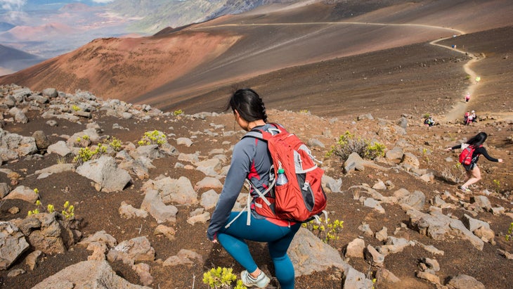
Is fleeing to Hawaii to escape winter a cliche? Maybe. But it’s only a cliche because it’s the right thing to do, especially if you’re making a point to explore Haleakala National Park, a 33,265-acre refuge that protects the 10,023-foot tall Haleakala Volcano, but also a large swatch of the coast on the northeastern edge of Maui. I had the chance to visit Haleakala with my family several years ago, and we enjoyed the contrast between the two distinct districts of this park. The Summit District encompasses a high-elevation, cinder cone landscape that’s often 20 degrees colder than sea level, while the Kipahulu District encompasses tropical forests, waterfalls and craggy coast near the small town of Hana. We enjoyed a frigid sunset from a perch 10,000 feet above sea level and the next day, hopped between swimming holes and beaches on our way to the town of Hana.
Temperatures vary depending on your elevation within the park, but you can expect highs in the 70s and lows in the mid 50s throughout Maui during the dead of winter. Haleakala is famous for its sunrise as seen from the peak of the 10,000-foot tall volcano (plan six months in advance for reservations, or settle for an incredible sunset without reservations) but that’s not the only reason to visit this park.
What to do
There’s plenty of hiking in the Summit District of the park (20 miles of trails) but the 11-mile Koeonehe’ehe’e Trail is the signature trek as it crosses the valley floor and climbs to the top of 7,990-foot Halemau’u. You’ll walk through the center of the crater floor along the way, as well as the brightly colored cinder cone called Pele’s Paint Pot.
If you’re looking for something a bit more “tropical,” head to the Kipahulu District of the park, which is the polar opposite of the Summit District. Instead of high-alpine desert, you get tropical forests full of waterfalls and lush foliage. It’s a commitment to get to this section of the park, though, as you have to drive 12 miles past the town of Hana on the Hana Highway along the northeast coast of Maui. But the drive itself is part of the adventure; the two-lane black top winds past waterfalls and swimming holes, beaches and tropical hikes. Honestly, this road was the highlight of our visit to the park. Once you make it to the district, hike the four-mile out and back Pipiwai Trail, which begins near the Kipahulu Visitor Center, and travels through a bamboo forest for two miles before ending at a view of Waimoku Falls, which drops 400 vertical feet over a cliff.
Where to stay
Maui is full of resorts, and I wouldn’t judge if you opted for that route. But the Kipahulu District has car camping with primitive sites, with no water or electric and only vault toilets, but you can pitch a tent in an open field overlooking the ocean. It’s 10 miles from the town of Hana, which has an amazing food truck scene ($20 a night, three night maximum, get reservations six months in advance).
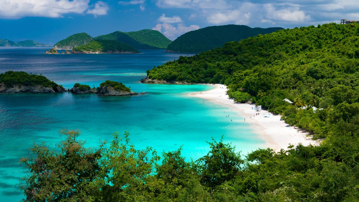
Virgin Islands National Park, St. John Island
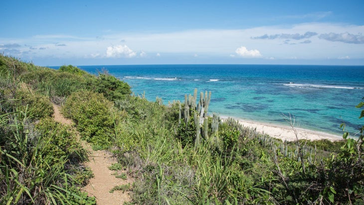
It’s not on the mainland, so there’s a logistical hurdle to get to Virgin Islands National Park, but flying to this archipelago from the east coast is pretty straight forward, and having to take a boat between the islands is part of the charm. My wife and I spent our honeymoon at Virgin Islands National Park many moons ago, and we have no regrets. Show up in February or March and you can expect temperatures peaking out in the 80s and dropping to a brisk mid 70s at night. Winter is also dry season in the Caribbean, so you won’t even have to contend with afternoon showers or the tropical storms that plague the area during summer and fall. The park covers more than half of the island of St. John, offering more than 20 miles of hiking trails and countless beaches and bays. It’s an island park, so plan on knocking out a mix of jungle hikes and laid back beach activities like snorkeling or paddle boarding.
What to do
Reef Bay Trail is arguably the signature hike within the park. It’s a tough 4.2-mile out and back that drops 900 feet on the way to a secluded bay, only to gain all that elevation on the way back to the trailhead. But you’ll see a bit of everything as the trail cruises under the biggest trees on the island, past sugar plantation ruins, and rock carvings made by the Taino people, who occupied the islands before Columbus sailed the ocean blue. The trail ends at Reef Bay Beach, which is only accessible by trail or boat. A barrier reef protects the bay from swells so it’s calm, clear water ideal for swimming or snorkeling.
Almost half of Virgin Island National Park is under water, and snorkeling is arguably the signature adventure within the park, with several calm bays offering reefs teeming with wildlife. If you want the instagram photo, head straight for Trunk Bay ($5 access fee), which is considered one of the prettiest beaches in the world. It also has a guided snorkeling trail along one of the coral reefs in the bay. If you want more eco-diversity, hit up Maho Bay, which has rock and coral reefs scattered along the edges of the bay known to attract angel fish and the occasional octopus, while the sea grass in the middle of the bay is healthy habitat for sea turtles.
Where to stay
Cinnamon Bay Beach, a campground inside the park, has tent sites, eco-tents, and cottages within walking distance of the sandy beach (from $50 a night for tent sites).
Graham Averill is Outside magazine’s national parks columnist. It’s been a busy winter full of ski trips for him, so he enjoyed taking a mental trip to these warmer parks for this article. He recently wrote about Deer Valley’s new terrain expansion.
The post The Best National Parks to Escape Winter appeared first on Outside Online.