… from the American Songwriter Alex Hopper")


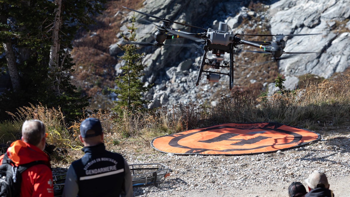
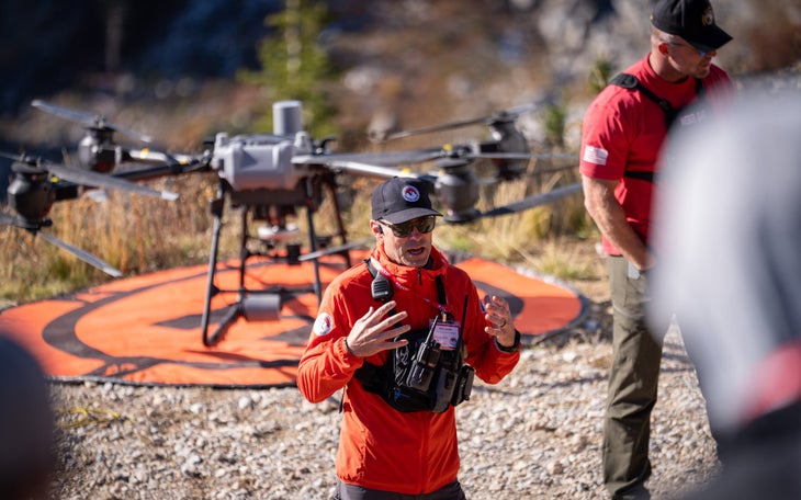
The Weber County, Utah, search and rescue (SAR) team has a new drone that’s the size of a chunky black lab, but with a ten-foot wingspan sporting 16 scything blades. The man piloting the DJI Flycart 30, commercial airline pilot Kyle Nordfors, is one of the nation’s foremost SAR drone pilots. Still, most in the crowd involuntarily lean back when the aircraft buzzes to life and lifts off.
Nordfors is demonstrating the massive drone and its uses to a group of rescuers from across the globe at the International Commission for Alpine Rescue (ICAR) conference. In the scenario, staged at Jackson Hole Mountain Resort, another drone pilot has already located the decoy “victims.” Now, Nordfors wants to deliver a 30-pound rescue litter, a stretcher in a metal basket, to the scene.
While he hovers the aircraft above the crowd, an assistant attaches the litter to the drone’s haul line, and Nordfors flies the cargo into the blue sky below the ski area’s famed Corbett’s Couloir. He tells the crowd that this “heavy lift” drone can shuttle up to 80 pounds of equipment to rescue sites, enabling personnel to complete a lifesaving mission faster and more safely.
The drone demonstration is one of hundreds of presentations at the three-day conference, hosted by Teton County Search and Rescue and drawing some 600 first responders from teams as far away as Poland and Thailand. Throughout the conference, SAR officials discuss how new technological innovations are rapidly changing the landscape for backcountry rescue.
Presentations about how smartphones interfere with avalanche transceivers take place alongside rescue dog workshops and talks about best CPR techniques. The entire symposium is organized with the goal of improving backcountry safety worldwide. Few topics, however, garner more attention than the use of drones in search and rescue missions.
Drones Are Already Saving Lives in the Backcountry
Drones have been billed as the cutting edge of SAR for several years. The small, remotely piloted craft can scan terrain far more quickly than ground teams can, and they can fly when conditions are too risky for helicopters, whether in darkness or in inclement weather.
Additionally, they cost a fraction of a helicopter. Nordfors says Weber County SAR has spent $90,000 to purchase 12 drones. Teton County’s SAR team, one of the few in the nation to own a dedicated helicopter, recently had to raise $7.2 million to purchase the chopper. Even with that asset, though, Teton County’s team is expanding its drone program, too.
“There are things drones can do that a helicopter can’t, and vice versa,” says Dr. Will Smith, Teton County SAR’s chief drone pilot. “Every time we take the drones on a mission, I get more ideas for things we can use them for.”
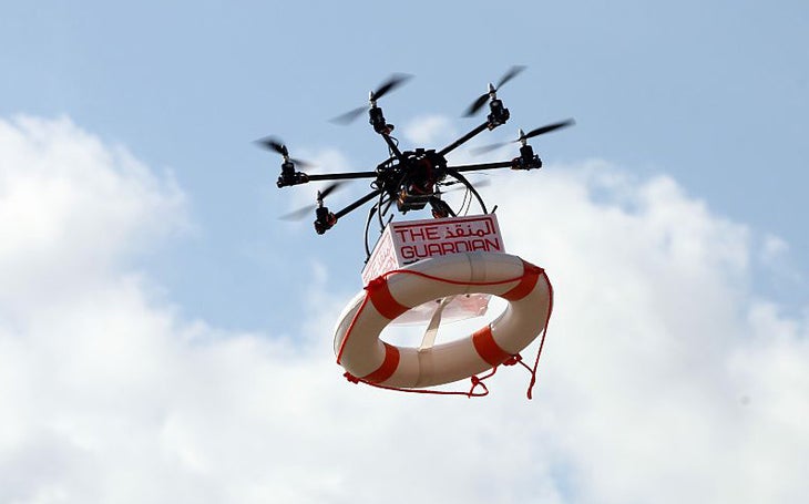
At the ICAR conference, experts presented their ideas: deploying the drones automatically from remote stations, a drone that doubles as a floating life ring to rescue swimmers, and even plans for aerial drones that can autonomously search cave systems. Yet none of these proposals is as keenly anticipated as one involving artificial intelligence.
Under one plan presented by Romania’s Salvamont mountain rescue team, computer programs will scour imagery taken by drones, and then analyze the photos using AI for signs of people who are missing in the backcountry.
It’s not an entirely new concept. This past summer in Italy, drones using such an app located the body of a climber who’d been missing for nearly a year by flagging red-colored pixels in drone footage that turned out to be the climber’s helmet. The search apps can be prompted to look for colors and shapes that appear out of place in the natural environment.
While such applications aide in body recovery, Nordfors believes that they are still inferior to a trained pilot in a rapid search. The program that found the missing Italian climber was a desktop-based application that requires an internet connection, something that most drones either don’t support, or is impossible in the backcountry. There are several programs that can be run offline, but the software can record false positives, and be slow and muddied, without connectivity.
“In my experience, I can still beat most of those programs to a victim just using my own judgement and understanding of lost person behavior,” says Nordfors, referencing a methodology used by many SAR professionals to predict where different types of lost persons tend to be found.
A Question of WIFI Connectivity
On the other hand, says Josh Duttry, who runs the drone program for La Plata County (Colorado) SAR, his team regularly uses the search software. Its optimal use, he told Outside, is for a secondary spotter to run the app on his or her own screen tethered via Bluetooth to the drone’s video feed. That way, the pilot won’t feel overwhelmed by the program’s shifting visual iconography.
“If the spotter sees something promising amongst the false positives, he can alert the pilot,” says Duttry. An IT specialist, Duttry also notes that calling such programs “artificial intelligence,” as the media often does, is a misnomer as they are not yet capable of machine learning.
What would change Nordfors’ opinion on AI use? If drones, most of which are currently controlled via radio frequencies, become equipped with satellite wireless internet connections, then the pilots could leverage the best cloud-based search programs.
“Internet connectivity would improve the video image quality as well,” says Nordfors, a boon to anyone, or any program, scanning the feed for signs of a lost person. That would require larger and more powerful drones than what most SAR teams are using as such equipment is heavy. Currently, the lightest portable satellite internet unit, the Starlink Mini, weighs 2.56 pounds. Both Duttry and Nordfors believe that such connectivity will arrive sooner rather than later, alongside improvements like longer battery life, which extends flight times.
Satellite internet connectivity would solve another of drone technology’s major limitations: radio frequencies don’t carry well around mountains or deep in canyons. Satellite-based internet signals could extend the range of drone searches into the remote locations where they are most needed. “With continuous satellite communication,” says Nordfors, “we’d really be able to get down and dirty into the canyons.”
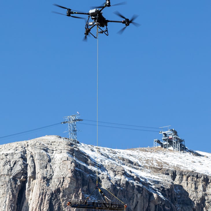
Also on Nordfors’ wish list? Clearance from the Federal Aviation Administration (FAA) to allow drones to transport humans. At least one drone model, the British-made Hydra 400, is capable of lifting as much as 800 pounds. Nordfors is working with the FAA to gather data on the aircraft’s capabilities, but the tests will take time.
“Getting approval for this will be at least as rigorous as the process that tech firms are going through with autonomous cars,” says Jason Ramos, a SAR drone pilot. “They’ve been working on those for 20 years.”
Thermal Cameras Are Already Making a Difference
The drone tech most likely to make a big difference for SAR teams right now is one that’s widely available. Thermal imaging cameras, which register a person’s body heat, are credited with an increasing number of successful searches every year. Nordfors’ most well-known search was accomplished with a thermal imaging camera, and is emblematic of the ideal use of the aircraft in a search and rescue setting.
On Christmas Day 2022, Weber County SAR was dispatched to Waterfall Canyon in Utah to assist a man who had been searching for his missing dog. The dog, Nala, had gone missing on Christmas Eve and spent the night out. When the team located the man, who was suffering from frostbite on his fingertips, he said he believed he’d seen his dog high on a canyon ledge.
Nordfors quickly located Nala using his thermal imaging camera and then pinpointed her location with a laser pointer, which registered directly to the team’s mapping software.
Next, Nordfors helped a pair of rescuers scout the best route to Nala’s location via a steep snowy couloir. He set the aircraft to hover above the scene, a practice that SAR teams refer to as overwatch, as a way to keep a second set of eyes on the scene to help anticipate needs or problems.
More SAR Teams Record Success Stories
Teton County SAR has found using drones for overwatch to be particularly helpful in swiftwater rescue scenarios. In 2025, the team performed multiple rescues involving cars that had veered into the river. “It’s important to know what’s coming downstream at the team,” says Smith, “or just keep an eye on rescuers operating in a hazardous environment.”
In Waterfall Canyon, as Nordfors kept an eye on his pair of rescuers high on the canyon wall, the drone came in handy in an unexpected capacity. Nala was skittish of the rescuers, and even while offering her beef jerky, they were unable to secure her. When the team realized that she was even more scared of the drone whirling overhead, though, they radioed Nordfors to steer Nala to them, and were able to get a leash on her.
From there, as darkness fell, the drone provided an overhead light for Nala and the rescuers as they made their way back down the canyon wall and to the trailhead. That light, says Nordfors, is amongst the drone’s most popular features with Weber County’s SAR team members.
“It lights up the whole scene,” he says, though the psychological boost may be more important than the practical, for both rescuers and victims. “That light in the darkness makes people feel like they aren’t out there alone.”
The post Drones and AI Could Transform Search and Rescue. One Hiccup Is Holding Them Back. appeared first on Outside Online.