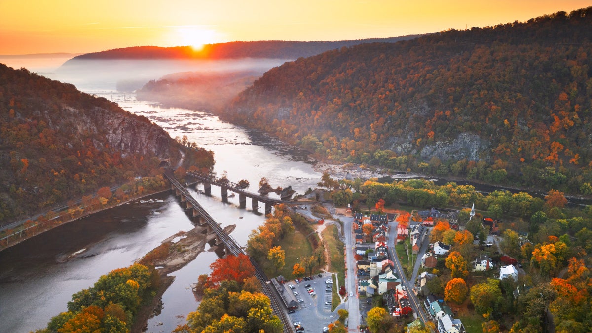

Think the beach is just for lounging? Think again. I found seven gorgeous hikes that trace the coast, from quiet beach walks to heart-pounding cliff treks. Some of these trails are multi-day affairs, giving you the chance to disconnect for extended periods of time, while others are quick day hikes designed to get you away from the summer crowds. Pack the reef-safe sunscreen, but maybe leave that trashy beach read at home — it’s time to hit the coast.
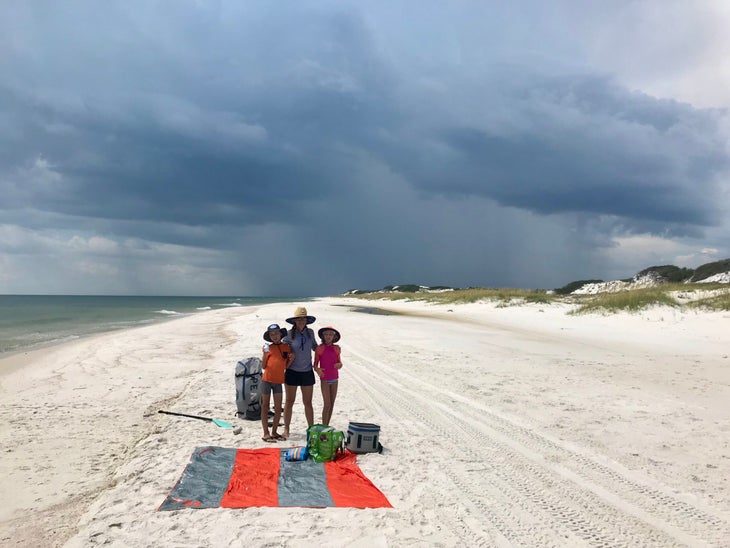
Mountains to Sea Trail, Outer Banks, North Carolina
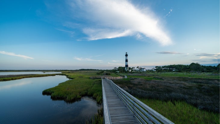
Distance: 82 miles
This is the dramatic finale of the 1,175-mile long Mountains to Sea Trail, which begins in Great Smoky Mountains National Park and ends at the Outer Banks, a string of barrier islands along the coast of North Carolina. Along the way the trail hits the tallest mountains in the eastern U.S. and passes through rolling farms in the Piedmont, but the last 82 miles is predominantly a beach walk passing between tall, grass-covered dunes and the Atlantic Ocean. This section of the Mountains-to-Sea starts in Ocracoke, which can only be reached by ferry, and does some island hopping through Cape Hatteras National Seashore. It’s a flat hike, although you’ll have the chance to climb the 208-foot tall Cape Hatteras Lighthouse, and the final push ascends the 100-foot sand dunes of Jockey’s Ridge State Park. Beyond the coastal scenery, I like this hike because it oscillates between isolated beaches and vibrant towns, including the charming Ocracoke Village, which still retains its fishing hamlet charm. You’ll also have the chance to surf, eat fresh seafood, and take flight (see below).
Best Campsite
Cape Hatteras National Seashore has four established campgrounds scattered throughout the islands. There are also plenty of hotels and cottages throughout the journey if you want to create your own inn to inn hike. But I like the tent sites at Ocracoke Campground, which has a row of sites on each loop that are just inland of the dunes, so you’re blocked from the wind coming off the ocean but have easy walking access to the beach ($28/night).
Know Before You Go
You’ll need to catch two ferries to complete this route (from $5 per person), and while you’ll spend most of your time on the beach, the MST moves away from the sand in a couple of spots, for a mix of singletrack and road walking.
Wildlife Watch
Legend has it that the “Wild Banker Ponies,” a herd of feral ponies that have been present in the Outer Banks since the first European settlers established homesites in the 1730s, are castaways from shipwrecks during the late 1600s. They used to roam free, but after the main highway was built in the ‘50s, the National Park Service moved them to a fenced-in pasture on Ocracoke to keep them safe from traffic.
Bring Your…Sense of Adventure
A number of surf shops offer lessons and board rentals along this route, and Jockey’s Ridge State Park operates a hang-gliding program where you can take flight from its tall dunes ($149 per person).
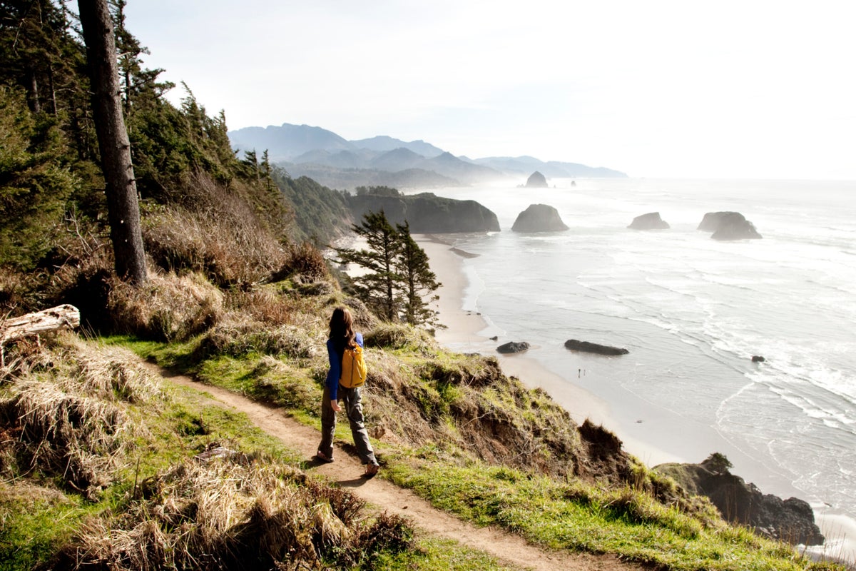
The Oregon Coast Trail, Oregon
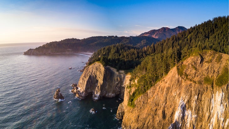
Distance: Up to 425 miles
The Oregon Coast Trail (OCT) sounds too good to be true: More than 400 miles of hiking along the Pacific Northwest’s coastal headlands, bouncing between isolated beaches, cliff tops, dense rain forests and the occasional fishing village. It might be the perfect coastal long hike, and the only problem might be that you can’t get away for the month or more it takes to complete all of it end to end. Fortunately, you don’t have to thru hike the Oregon Coast Trail to enjoy its goods. The OCT is broken into 10 sections of varying lengths, each of which can be knocked out in shorter multi-day stretches. What’s the best? Arguably Section 1, a 36 mile jaunt that begins at Oregon’s border with Washington, where the Columbia River divides the two states, then travels south through the beach of Fort Stevens State Park, where you’ll see the historic Peter Iredale shipwreck, before climbing to the top of Tillamook Head, a cliff that stands 1,200 feet above the Pacific. Hikers will also see the iconic Haystack Rock, a seastack rising from the surf, and get to hit the beach town of Cannon Beach before finishing the hike in Oswald West State Park.
Best Campsite
It’s hard to beat the three Adirondack-style hiker shelters on Tillamook Head, each of which has four first come, first serve bunks. You can pitch a tent in the area if the bunks are full. A short walk from the shelters to the edge of the cliff gives you a view of the Tillamook Lighthouse, which sits on a rock a mile offshore.
Wildlife Watch
Keep an eye out for gray whales, which are headed north to Alaska along the coast during spring (from March to June).
Know Before You Go
Some sections of beach, especially near the southern end of this section in Ecola State Park, can only be crossed at low tide, so check NOAA’s tide charts before starting your hike. Also, if you try your hike in the spring, rivers might be too high from snow melt to ford.
Bring Your…Appetite
The fish doesn’t get any fresher than what you’ll find in the coastal towns like Cannon Beach and Seaside, both of which have long-standing fishing traditions where boats provide restaurants with catch taken from the sea daily. Ecola Seafood is known for using line and hook methods (no nets) to catch the fish they sell. Fish and chips, with halibut or cod, depending what’s in season, are a staple.
Loop Trail, Santa Rosa Island, Channel Islands National Park, California
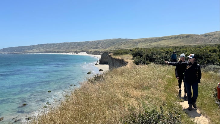
Distance: 7.5 miles
The Channel Islands, off the coast of Southern California, offer one of the most unique hiking experiences in the country. Five of the eight islands are protected as a national park and essentially offer a glimpse of what Southern California was like before development took over. I had the chance to visit the park on an expedition cruise, and Santa Rosa Island was the highlight thanks to its tall cliffs, endemic species, and hiking trails that are full of eye candy. I like the 7.5-mile Loop Trail, which starts at the pier in Becher’s Bay, passes through a historic ranch with expansive grasslands, and climbs up to a grove of Torrey Pines overlooking the Pacific. From there, the hike drops back down to the edge of the cliffs above the ocean. On your way back to the pier, you can either hike a mix of the coastal road and singletrack that hugs the edge of the cliff, or drop down to the Water Canyon Beach and hike the two-mile long stretch of white sand back to the pier.
Best View
There’s no bad view along this hike, but the perspective from the grove of Torrey Pines gives you a broad field of vision that takes in the grasslands, cliffs, and Pacific that stretches on for eternity.
Wildlife Watch
The Channel Islands are considered the “Galapagos of North America” because the islands evolved in isolation and have 23 endemic species. I saw a bunch of cool animals during my time on the islands, but the native fox was the cutest; at roughly the size of a house cat, it’s one of the smallest species of fox in the world. I was fortunate enough to see one in the shade of the Torrey Pines during my hike.
Know Before You Go
You’ll need a boat to reach Santa Rosa, or you can hop a ride from Island Packers, which runs a ferry from Ventura and drops off hikers, backpackers, and kayakers at the pier in Bechers Bay. There are three day trips to Santa Rosa a week (Wednesday, Friday, and Sunday/$95 per adult) or you could spend three days/two nights on Santa Rosa, and grab one of the 15 sites at the island’s small campground ($15 a night). Some of the beaches are open seasonally to primitive camping (check the national park’s website for the current closures when you’re planning your trip).
Bring Your…Love of History
The native Chumash thrived on Santa Cruz for 10,000 years, developing a society that was based on trade and a shell bead currency. Cultural sites can be found throughout the island, but you’ll also find some native plants that the Chumash depended on, like the delicious lemonade berry, which tastes like…lemonade.
Chapel Loop, Pictured Rocks National Lakeshore, Michigan
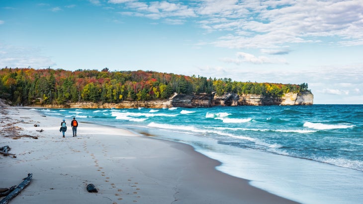
Distance: 10.5 miles
Think there’s no coast in the middle of the country? Think again. Pictured Rocks National Lakeshore protects some of the wildest coastline in America, with miles of sandstone cliffs dropping to the water, isolated beaches, sand dunes, even waterfalls. It just happens that the coast we’re talking about is on Lake Superior. There are a lot of short hikes in the national lakeshore that lead to scenic views of the lake. The best of these has to be the 2-mile round trip from Miners Castle to Miners Beach, a mile long, narrow stretch of sand flanked by green, pine forest and cliffs. For a bigger adventure, hike the 10.5-mile Chapel Loop, which takes in the area’s history and scenic glory, as it passes multiple waterfalls tucked into the pine forest before tracing the edge of the cliff above Lake Superior where you’ll cruise by the iconic outcroppings of Indian Head and Chapel Rock. Hikers will also have the chance to lounge and swim from two beaches, Mosquito Beach, which is flanked by sandstone cliffs, and Chapel Beach, which sits at the mouth of Chapel River with a view of Chapel Rock, a sandstone arch with a solitary pine tree perched on its expanse.
Best View
Lover’s Leap is a broad sandstone arch that stretches from the band of cliffs out into Lake Superior’s clear waters north of Mosquito Beach. You can see the arch from various points along the trail between Mosquito Beach and Miners Castle.
Know Before You Go
During the summer, the Chapel Loop parking lot fills quickly (often before 9 A.M.). Multiple trails leave from the parking lot, so hikers spread out throughout the park, but you’ll need to be an early riser to get a space.
Wildlife Watch
The diversity of species in Pictured Rocks is impressive, ranging from the occasional moose to the gray wolf and bald eagle. Keep an eye out for the piping plover, a small, white shorebird that’s listed as endangered but is known to live within the national lakeshore. You’ll likely see them hunting for food along the beaches.
Bring Your…Kayak
The hiking in Pictured Rocks is great, but kayaking along the shoreline offers the best views of the sandstone arches and waterfalls that tumble into the water. Don’t have your own boat? Pictured Rocks Kayaking offers tours where they launch from a larger boat offshore to cut down on the miles you need to paddle (from $99 per person).
Lost Coast Trail, Kings Range National Conservation Area, California
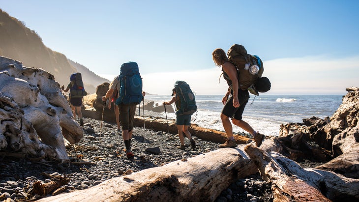
Distance: 25 miles
You can’t write an article about coastal hikes and not include this Northern California gem, which traverses 25 miles of cliffs, waterfalls, and black sand beaches through the King Range National Conservation Area, managed by the Bureau of Land Management (BLM). The Lost Coast earned its name because the wilderness area was too rugged for highway construction (elevations reach 4,000 feet just three miles from the ocean), so a 35-mile stretch of coast between the small towns of Shelter Cove and Petrolia, California was lost to development. It has since become a hotspot for backpackers looking for secluded beaches and grand views. It’s become so popular the BLM has had to limit visitation; a permit system caps use to 60 hikers per day between May 15 and September 15 and costs $6 per night as well as an additional $12 “special area fee” per hiker. You can get permits three months in advance on a rolling basis. But if you score a permit, you’ll have two to four days of mostly beach hiking with 100-foot-tall bluffs on one side and iconic California waves on the other. Beach camping, the occasional waterfall, and the chance to climb Punta Gorda Lighthouse, round out the highlights.
Best Campsite
There are no designated campgrounds, but the various creeks that meet the beach make popular campsites that will have reliable water. The Sea Lion Gulch site, at mile 4.5, sits on the edge of the bluff, offering big views of the beach below and Pacific beyond, but you’ll likely deal with windy conditions. Big Creek, at mile 9.5, is the most popular campsite with sites at the mouth of a broad creek that travels through a narrow, fir-covered gorge before meeting the beach. You can choose from beach sites or forested sites away from the wind.
Know Before You Go
High tides create impassable zones on three sections the Lost Coast Trail, where the water swallows the thin beach until it retreats. Plan your hike according to the tide forecast and time your trek across these beaches as the tide is retreating to give yourself the biggest window.
Wildlife Watch
Elephant Seals are huge, weighing up to 8,000 pounds, and were once in danger of becoming extinct, but they’ve found safe breeding ground on the isolated beaches of California’s Lost Coast. You’ll see them throughout this journey, including a large colony that can often be found lounging in the sun near the Punta Gorda Lighthouse. During the summer, these animals come ashore to shed their outer layer of skin.
Bring Your…Telephoto Lens
Your chance for cool wildlife photography is off the charts on the Lost Coast Trail, from deer grazing the grasslands to black bear and the aforementioned elephant seals. Bring a telephoto lens and keep your distance while you snap away.
Wilderness Trail and Beach, St. Joseph Peninsula State Park, Florida
Distance: Up to 12 miles
T.H. Stone Memorial St. Joseph Peninsula State Park (that’s a mouthful!) protects 20 miles of Cape San Blas, a primitive peninsula that divides St. Joseph Bay from the Gulf of Mexico off the coast of mainland Florida. Head to the northern tip of the cape, which is protected as wilderness, and you’ll get legitimate deserted island vibes, as the wilderness area has been undeveloped, giving you a sense of what Florida was like before the condos and theme parks. The six-mile Wilderness Trail passes through the center of the cape between gnarly pines and oaks, with optional trails to the Gulf side of the peninsula giving you the opportunity to create a loop hike (or out and back) of your choice where half of your mileage will be on sugary white sandy beach. A beach access trail begins at the parking lot and another can be found three miles up the beach, making for an ideal six-mile loop. Tall dunes topped with sprouting sea grass line the interior of the beach throughout the hike, and the sand is so fine and powdery that it will squeak beneath your feet as you walk. Hurricane Michael split the peninsula in half in 2018, and damaged much of the park’s infrastructure, but the divide has been filled in and the wilderness area of the park has proved to be resilient, bouncing back to its former glory in the several years since the hurricane. Bring your bathing suit and beach supplies; there are no services in the wilderness area, and the Gulf water is warm and ripe for swimming and snorkeling.
Best Campsite
You can treat this hike as a day-long excursion, but the Wilderness Preserve has 14 primitive campsites tucked into the dunes and palms. Site #14 sits at the end of the Wilderness Trail, on the water, in the shade of a handful of palm trees ($5 per night, per person).
Wildlife Watch
My family and I camped at this state park for spring break one year, and we spent most of our nights battling a feisty raccoon who had plans for our cooler. But the park is brimming with more fun wildlife, including the snowy plover, an endangered migratory shore bird that nests on the peninsula.
Know Before You Go
You need a permit to explore the Wilderness area. You can pick one up at the state park’s ranger station on the day of your journey. Be sure to be back at your car and exiting the area an hour before sunset, a rule that helps protect the various nesting animals on the cape.
Bring Your…Paddleboard
The state park has several kayak launches, giving you the chance to paddle the calm and clear waters of St. Joseph Bay or the Gulf of Mexico.
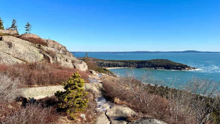
Gorham Mountain Loop, Acadia National Park, Maine
Distance: 3.5 miles
This short loop captures some of the best terrain in Acadia National Park, allowing hikers to scramble up and over cliffs, hit a summit with long range views, and drop down to the edge of the Atlantic. The best part? Unlike summiting Cadillac Mountain, you don’t need to score a permit to hike Gorham Mountain. There’s a good mix of terrain too, from dense spruce and pine forest to cliffs and beaches. Be sure to tack on the .3-mile Cadillac Cliff side trail and you’ll climb ladders and iron rungs up and over cliffs that were formed when sea levels were much higher than they are today. From there, climb to the summit of the 525-foot Gorham Mountain, where you’ll have a view of Cadillac Mountain on one side and the Atlantic on the other, before dropping down to the ocean, passing a freshwater pond along the way. Once you hit the coast, you can take a dip at Sand Beach before continuing on Ocean Path to the iconic Thunder Hole, a sea cave that catches waves from large swells creating a thunderous boom, before returning to the Gorham Mountain trailhead.
Best View
There are iconic Maine coastal views throughout much of this hike, but it’s hard to beat the all-encompassing view from the summit of Gorham Mountain, where you can see the rugged coastline below, including Sand Beach, and the Porcupine Islands rising from Frenchman Bay.
Know Before You Go
While you don’t need a permit to hike Gorham Mountain, the parking lot fills quickly, often by 9 A.M. on weekends, so start your hike early if you can. Or consider taking the park’s free shuttle, the Island Explorer, which you can pick up at various points throughout the park and neighboring communities.
Wildlife Watch
Acadia National Park is one of the best birding locations on the east coast, with more than 300 species identified inside the park. One of the most exciting species is the peregrine falcon, which has rebounded from the edge of extinction and has been documented breeding and nesting on various cliffs inside Acacia. In the summer, you can see fledglings learning to fly near Cadillac Mountain.
Bring Your…Bathing Suit
Sand Beach, which is comprised of crushed shells, is the largest beach inside the park and a popular spot for swimming. Brace yourself for a cold plunge though, as water temps rarely hit the 60s, even in summer.

Graham Averill is Outside magazine’s national parks columnist. He likes any hike that ends at the beach. He recently wrote about the best small adventure towns in the U.S. and quiet destinations where you can escape the noise of modern life.
The post The 7 Most Beautiful Coastal Hikes in the U.S. appeared first on Outside Online.